
 Serbias' Autonomic Province Vojvodina for the period 2009-2020 was prepared and was put on public examination. The last and at the same time only such document was managed 33 years earlier, and it aimed the year 2000. It is said in the media campaign that follows the public participation, that the Regional Spatial plan of Vojvodina is a long-distance strategic document which aims to direct continual and harmonized spatial development of the Province, to raise economic efficiency, sense of social justice and security, to aid rational use of natural resources and to help the rural development.
Even a glance look at the documentation presented reveals clear emphasis given to the "green" infrastructure and that the planners had in mind the future Natura 2000 network. At the other hand, it is also true that most of these green areas shown over the urbanistic and industrial (red) layers were "justified" with the phrase barren, or non-agricultural land, which is by itself a fact, e.g. in the case of Pannonian saline plains. The elements of urban expansion were taken into careful consideration, and good balance had been achieved for the cities not to devour themselves up, but rather to have remainders of "natural" environment around them in form of arable lands, forests,
 wetlands and even nature conservations where organisms hunted, angled, abused by the inhabitants of those cities have a chance to survive. It is enough to mention one example of the pressure on the nature, the lake nearby Subotica where anglers already occupied all of the reedy shore, parceling it out by mutual agreement for individual mole building (picture). Since lake Palic is polluted and poor in fish, anglers moved over and by now at least 200 moles were built here...
Looking at the reference maps of the spatial division environmentalists can get a feeling that the need for NGO lobbying in Vojvodina for more percentage of protected land has gone. However there are some disturbing facts:
1) the spatial plans put on paper have had a tendency not to fulfill all but little that was proposed - there is a fear that this plan may end up like the LEAP in many parishes, where none of the environmental improvement plans came accomplished, for the lack of money and because of corruption (although there is an advantage over the LEAP, the legal system of the EU that is also the only chance for the actual accomplishment of this spatial plan)
2) the state of natural environment in many parts of Vojvodina is so catastrophic at the moment, that without huge investments it cannot be revitalized. Environs of the valley of Čik creek - an example we will examine closely - that is marked on the map as "of high importance for nature protection in assessment phase of value estimation" is so highly fragmented that it is impossible to achieve its former stage without radical intervention. Which may include: a) land repurchase or b) education of and redirecting farmers to extensive forms of rural management e.g. cattle pasturing c) planed revitalization with reintroduction of formerly disappeared local plants and animals, maybe even of those ethnographic landscape elements of ruined local ranch systems called "salaš". The only serious chance for this transposition of status of the land is the introduction of Natura 2000 with it's subsidiary systems and EU financing models.
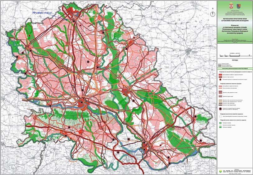
If we examine the extent of the areas that are presented in the Plan as "non-arable land" or land under different aspects of international and local protection we can be satisfied. One can see that maps were prepared in accordance with the EU standards. If the officials responsible for the processing of the spatial plan were faithful to the sketched parameters, nothing else is left to environmentalists but to step behind it, and give full support by admitting data from our field diaries, of important species that can only back-up the need for protection. The territories designated for green corridors will draw back many organisms expelled from theirs historic ecological ranges, and these corridors will promptly become, if they aren't already, hot spots of biodiversity. We all know that given a chance, nature can recover.
Nevertheless, it was not intended to give detailed analysis of the Plan, but to encourage by presenting that the idea of Natura 2000 takes forward leaps in Vojvodina. But does it?
The part that stands out for our interest
 is the "Report of strategic environmental impact assessment of the Regional Spatial Plan of Vojvodina" in which in the spatial differentiation we have environmentally degraded areas (red shades) and areas of quality environment (green). Further in these are three categories: a) Natural heritage b) Ecologically important areas c) Green corridors. In the corresponding documentation of the Plan future Natura 2000 areas are mentioned within these zones. Knowing that in many EU countries protected land proportionally extends over Natura itself, we can still be satisfied - at least with the maps. Who ever prepaired them, had really good stuff in mind. But how real-y here in Vojvodina? What is the actual situation in the field? What is the quality of the proposed areas, and how much we need to invest to return them into "ecologically favourable" state?
One particular example
 Creek Čik is one of the five historic streams of Bačka region (they are Mostonga, Plazović, Krivaja, Čik, Kireš). Its geologic meander is 50 to 150 meter wide. By designating a kilometer wide corridor the planners here had - rightfully - taken into consideration the former state, when the creek filled it's whole valley together with its appropriate biotopes. The real geomorphologic and ecologic characteristics of the terrain are calculated. But on the other hand satellite pictures reveal that the actual stream today is narrowed to a channel, that is ploughed around, deepen and cleaned periodically, so it completely lost the features of a natural stream that once collected the waters of the loess plateau of Bačka.
But it is not right that a landscape be so catastrophically restructured, only to gain few more hectares of arable land! In these loess plateau valleys the underground water
 frequently destroys crops, and this is well known to these farmers so they even call these parcels "a valley". We hear from them: "Eh, nothing yields in the valley, I wonder what to do!" But they inherited the land together with the only cultivation technique they know: ploughing. As a result, it's not rare to see that the only "crop" that produces on the parcel ploughed all the way to the channel - is reed! These farmers have to ask themselves if their agriculture is profitabile? If a farmer would get a subvention, a withdrawal from tax or such, with appropriate education about the Natura 2000 he would voluntarily consent to return that hundred-meter-wide land strip to the nature where it belongs! The farmer gets, and we all get out of it. However, it's important to say, that because of adverse agricultural politics our livestock-farming suffers, so keeping animals on the pastures that would naturally develop - thus returning the landscape its historic atmosphere - isn't in the minds of our farmers. Last but not least, signing the Landscape Convention, Serbia must again start propagating extensive animal-farming, rather than to continue to import cheap (but sometimes more expensive) milk, meat etc. not to go deeper in the waters of agri-economy...
For an example we will take a fragment  of the presented ecologic corridor near Subotica. "Hrvatski majur" is one of the microhabitats in the valley, situated about 6 km southwest to the city. Habitat miraculously survived because the creek here forms a swampy zone, which eventually got "engaged" by the hunters. So this way it remained in nearly natural state. Now it is a fen with periodical water, reeds, sedge and grasses in succession with phytocenose of Narrow-leaved Ash (Carici-Fraxinetum angustifoliae) that forms a grove circle around the habitat. If our estimation made according to referral maps is right, this microfragment of about 5 hectares will get into the planned corridor and with it potentially into Natura 2000 area. It would be appropriate, as Large Copper (Lycaena dispar) inhabits it, a butterfly from the Habitat Directive (Annex II/IV). However, if we look at the shape of the corridor we find that it is about a kilometer wide space. It is unrealistic, but of course would be nice if there was way to place it into the system of Natura. The problem is that these are mostly private parcels sold by the government (and sometimes given for long-term rent) long ago. The owners will need subventions if we want them to return their property into former state. It is right to believe that without direct help from EU such transposition will not be possible.
 of the presented ecologic corridor near Subotica. "Hrvatski majur" is one of the microhabitats in the valley, situated about 6 km southwest to the city. Habitat miraculously survived because the creek here forms a swampy zone, which eventually got "engaged" by the hunters. So this way it remained in nearly natural state. Now it is a fen with periodical water, reeds, sedge and grasses in succession with phytocenose of Narrow-leaved Ash (Carici-Fraxinetum angustifoliae) that forms a grove circle around the habitat. If our estimation made according to referral maps is right, this microfragment of about 5 hectares will get into the planned corridor and with it potentially into Natura 2000 area. It would be appropriate, as Large Copper (Lycaena dispar) inhabits it, a butterfly from the Habitat Directive (Annex II/IV). However, if we look at the shape of the corridor we find that it is about a kilometer wide space. It is unrealistic, but of course would be nice if there was way to place it into the system of Natura. The problem is that these are mostly private parcels sold by the government (and sometimes given for long-term rent) long ago. The owners will need subventions if we want them to return their property into former state. It is right to believe that without direct help from EU such transposition will not be possible.
So we conclude it may be early to applause to the environmentalists that stand behind the spatial plans because of the terrific other side - that reality of deteriorated and degraded land, that we cannot stress enough. It is easy to draw a map or place an area into a database, but where are the finances to carry out the "favourable conservation status"? [phrase that occurs repeatedly in HD and BD Articles] Nothing else is left to us, than to wish all the best to the state in the implementation of this plan, and to contribute to the development of nominated protected areas with as much as possible biogeographic field data!
Hvala Jozef, uključit ću ovo u sljedeće izdanje newslettera!
OdgovoriIzbrišiOfficial pages (in Serbian):
OdgovoriIzbrišiRegionalni prostorni plan AP Vojvodina - Republička agencija za prostorno planiranje